

Costa Rica
Costa Rica
Once an agriculture-based economy, today it sees the eco-tourism as its main way of living. Given its beaches and coastal plains near the sea shore and the giant green mountains in the centre of the nation, it has several ecosystems that can offer different sorts of exhilarating activities.
Activities
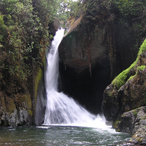
Tourist activities allow deeper understanding of natural and cultural tourist attractions, as well as a close relationship with nature, adventure and sports and recreation.
The activities you can enjoy in this area are listed above, as well as their brief description.

Photography
Diverse flora and fauna in natural areas, stunning coastal landscapes and cultural interest make taking photos and video a highly popular tourist activity.
Adventure Tours
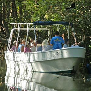
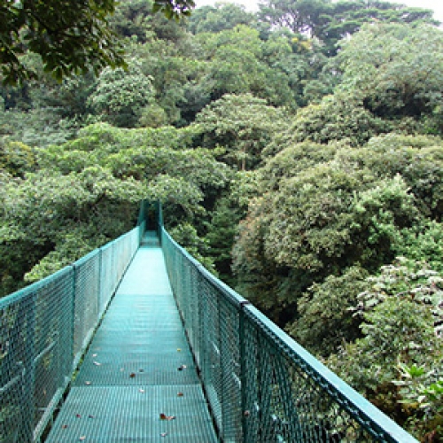
Well developed for tourism, the Quepos–Manual Antonio area is very attractive to tourists, offering mountains and high places as well as quadricycle or all-terrain-vehicle tours. Tourists can walk over suspension bridges, tour mangrove swamps by boat, visit butterfly gardens, go horseback riding, dolphin- or bird-watch, go sport-fishing or enjoy an ultralight flight.
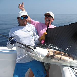
Sport-Fishing
Sport-fishing is one of the Central Pacific’s main attractions. Artisan, recreational or challenging sport-fishing may all be enjoyed in the Quepos area.
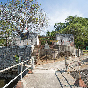
Architectural and Historical Sites
The city of Puntarenas features a small old town with the characteristics of a historical center. There are buildings of architectural and historical interest as well as National Monuments, such as the old Port Military Headquarters facilities, Parque Mora y Cañas and the Central Church. San Lucas Island and the old San Lucas Penitentiary may also be visited.
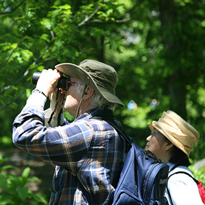
Bird-watching
Bird-watching can be enjoyed in various public and private protected areas, including Manuel Antonio National Park and Parrita as well as other fine spots.
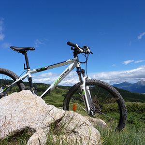
Recreational Cycling
The region features picturesque roads and adventure or relaxation sites for touring on regular or mountain bikes. Beaches and mountains also make interesting rides.
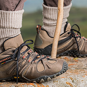
Hiking
Hiking is a good way to take in various tourist attractions: natural parks, beaches, ecotourism trails, historical buildings, architectural monuments or cultural tours around various communities of interest.
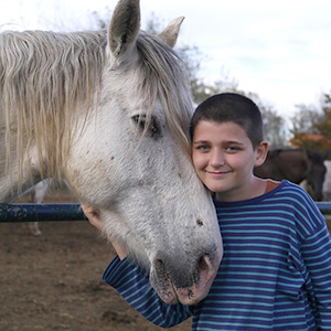
Horseback Riding
This activity may be enjoyed on the coast, in the communities or in the mountains of this region. Horseback tours are offered by tourism companies, landowning associations or families that rent horses.
Cultural Activities
Throughout the year, community activities are held celebrating historical, religious, sporting, civic or artistic events. Fairs are also held to raise funds for community development.
February
- 22-26 -> Buenos Vecinos International Jazz Festival, Quepos.
- Last week of February. Puntarenas Carnival.
April
- After Holy Week. National Fruit Fair, Orotina.
May
- 1 -> Labor Day.
June
- 3-16 -> Virgin of the Sea (Virgen del Carmen) Festival.
August
- 24 -> National Parks Day.
September
- 14 -> Lantern parade.
- 15 -> Costa Rican Independence Day.
- 30 -> Commemoration of Mora y Cañas’s death, school parades, city of Puntarenas.
December
- 8 -> Feast of the Immaculate Conception, Quepos.
- 25 -> Christmas.
Rural Tourism and Services
About rural tourism, the activities and services offered are as follow and located in the corresponding geographic areas of the North Pacific:
Ecotourism Refuge Monte Alto located at 4 kms. from the Hojancha center.
Activities: Hiking by natural paths, waterfalls visits, orchid garden travel, visit to the “trapiche”.
Ecotourism Bolsón located in the community of Bolsón, characterized by giving a several staying services in houses of Ortega and Bolsón. They’re prepared families for the reception of tourist.
Activities: Trips by the Tempisque River and National Park Palo Verde for the observation of crocodiles, birds and monkeys among others.
Located in Santa Bárbara of Santa Cruz, next to the School, Casa del Sol is a project that supports the use of solar energy.
Activities: It could be tasted solar energy prepared food.
Regions
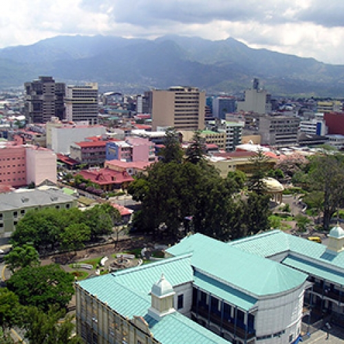
San Jose and the Central Valley
San Jose and around half of Costa Rica’s population are situated in a region known as the Central Valley. With an elevation of about 1,200 meters (nearly 4,000 feet), and a pronounced dry season, the climate of the Central Valley is so nice, it’s no wonder that such a high percentage of the country lives there. The temperature reaches the upper 70s or low 80s most days, and nights are usually in the 60s. Dry, breezy weather predominates from January to April while afternoon rains fall for the rest of the year. Being the capital of Costa Rica, embassies and consulates are found here as well as the offices of large businesses and corporations that work in the country. Other mid-sized cities are found in the Central Valley and so is the Juan Santamaria International Airport. Since much of the Central Valley is urbanized, this is the place to go for business and city life. Nevertheless, Costa Rica is so small that a short drive will quickly take you from the concrete of the city to the coffee farms, mountains, and tropical forests of the surrounding countryside.
Guanacaste and the Nicoya Peninsula
Located in north-western Costa Rica, this is a region of windswept savannahs, cattle farms, and cowboys. For folks who feel a need to escape the rains of more humid regions, Guanacaste beckons with hot, dry, sunny weather except during the rainy months of August to November. Guanacaste is also famous for its many beaches. While some are suitable for surfing and others for swimming, they are all good for sun, sand, waves, and warm, tropical water.
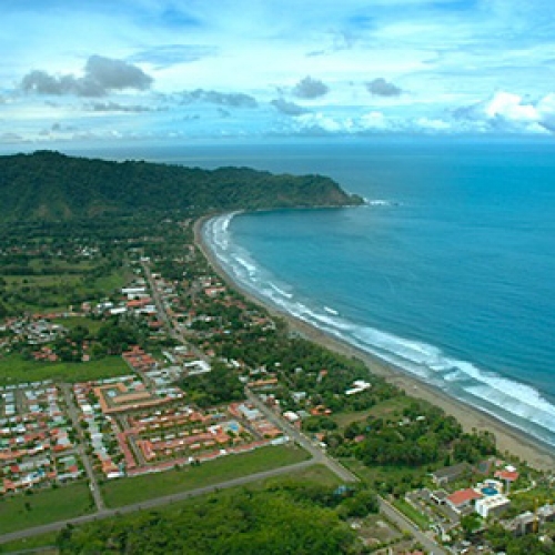
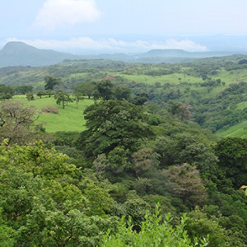
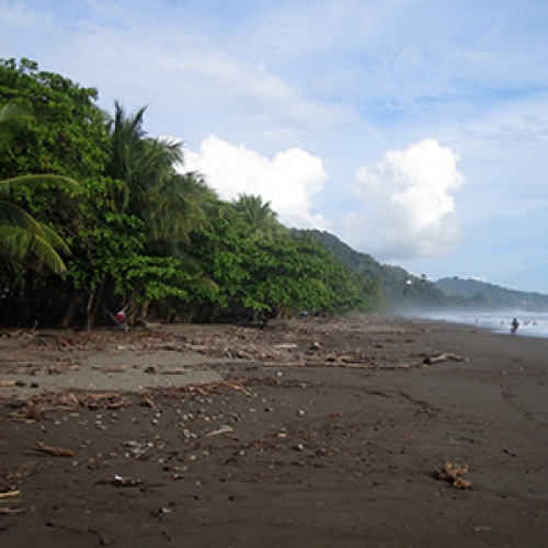
The Central Pacific Coast
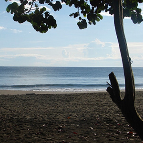
South of Puntarenas, as the climate becomes more humid, rain forest and oil palm plantations replace the dry, windswept plains of Guanacaste. Most of the attractions of this region are found along the narrow coastal plain that is flanked by the Pacific Ocean to the west and mountain ranges to the east. The beaches and national parks of the Central Pacific are some of the most visited in the country and the waters off the coast offer some of the best deep sea fishing in Central America.
The Southern Pacific
South of Dominical, the Osa Peninsula juts into the Pacific like a big, rebellious toe. The wild rain forests and mangrove swamps of this jungle wilderness beckon to visitors looking for adventure while a short drive to the east brings them to the Panamanian border.
The Talamancan Mountains and El General Valley
The massive Talamancas rise into the clouds to the south of Cartago and are the highest 14 mountains in Costa Rica. Visitors can trek through their cool, montane, rain forests on the way up to Chirripo, Costa Rica’s highest peak. In the groves of immense, moss-covered trees, hikers might see the Resplendent Quetzal (a bird so spectacular that the Mayans thought it was a messenger of the Gods), or glimpse a Central American Tapir as it crashes away through the undergrowth.
Monteverde and Arenal
A region of cloud forests, rain forests, immense wetlands, cattle farms, and the most famous active volcano in Costa Rica, this part of northern Costa Rica is the best area in the country for letting the volcanic hot springs soak away the tensions and worries of everyday life.
The Caribbean Lowlands
Mainly populated by the descendents of Jamaicans and indigenous peoples, this area of Costa Rica is an interesting mix of cultures with that of the Caribbean Islands holding a prominent place. Due to their Jamaican heritage, many people speak English and the Rasta way of life is commonplace. The port of Limon is the capital of this region although most visitors looking for the beach spend their time in the small seaside towns of Cahuita and Puerto Viejo de Talamanca. Ecotourists spend more of their time in the rain forests of the Sarapiqui and Tortuguero regions.
Attractions
The access road that communicates with these beaches is traced in its north side over the San Miguel hill, from where there is an impressive sight of this open coast. Both beaches form the same coast sector, but they are separated between them by the outfall and estuary of Jabilla that forms an extensive mangrove swamp. The surge in these beaches is strong and continuous. San Miguel has a length of 3 kilometers and Coyote nearly 5 kilometers up to the estuary of the same name. This littoral is ideal for boat rides or small launch, the resting, the sea watching, walkings and horse riding as well as sight of vegetation and fauna of its mangrove swamps.
It’s a bay of about 4 kilometers length. Presents a moderate surge. It has mangrove swamps and littoral vegetation: manzanillos, cocoteros, low soil plants such as the beach bean, etc. To the central side of the beach there is an old and big tree of “Matapalo” that’s distinctive of Sámara. To the south extreme and in front of the point Indio it’s located the Chora Island. Take the sun, do some hikes and horse rides, be in the sea, ride mountain bike, ride in boat or kayak are some of the activities of this beach that counts also with a varied tourist services that allows the enjoy of the beach during the day, music and a good dinner at night. It has the Bandera Azul declaratory.
It’s a bay of short extension and in horseshoe shape, with smooth surge. The littoral landscape around is very beautiful and from its coast it could be see to the north the Palmitas (Eggs) islands.
These are beautiful inlets of few extension and vast littoral vegetation. Both are communicated among themselves by a rock platform that joins the north of the ends Trinidad y Pleito. The beach of the last one presents on its south extreme a beautiful turn, ideal for bathing. San juanillo offers the particularly of have nice end (Trinidad), which is formed by a small golf of fine sand that made to the north a covered place with few surge and to the south it extends itself a few more hundred meters forming inlet of Cocal Beach.
To it’s north extreme is located the Nosara end, which separates itself from this last beach. It’s ideal for the hikes and rest. In the south side is a rock end, where is a beautiful scenery of this beach and guiones beach, which extends to the south. It could be realize hikes, horse riding, sunbaths, sport fishing and snorkeling.
It’s an extensive beach, wide and with strong surge that joint to the south with Nosara beach, separated by an end called División. This beach has worldwide prestigious, because in it and Nancite (National Park San Rosa) where arrives to nest in major quantities the Lora turtles, especially from july to November. Because of this reason, this beach and all the coast to the south up to Punta Guiones, forms part of the National Refuge of Wild Life Ostional. The most scenery of this beach is located to the north where the coast is rocky.
It’s a beach with a beautiful estuary and wide mangrove swamp (Nosara River) that could be traveled on boat and kayaks, to sight its vegetation and fauna, especially birds. In the Nosara town and proximities there are all kind of tourist services, included the horse tours and in kayak.
This coast sector presents rocky beaches to the north (Lagarto, Manzanillo) and sandy to the south. To the north, Lagarto distinguish itself by its hand fishing activity. This part of the coast is beautiful, but has few tourist services. To the south there are beaches like El Coco, Marbella and Pitahaya, where there could be made hikes and ocean baths. In Pitahaya, to the north extreme, there is an attractive protected seaside. These beaches are visited by Surfers because of their surge.
It’s a cove in shape of half moon and has few surges. Its name comes from the presence of a rocky island next to Punta Islita in the northeast extreme of the bay. It has two estuaries that complements the beauty of it’s landscape, which could be enjoyed fully from the high side of the road that communicates to the south with Corozalito, where could also be sight high steeps. The activities that could be made besides the baths and taking the sun includes hikes and horse rides, tours in 4×4 wheels, mountain cycling and boat rides for fishing and diving. It has the declaratory of Bandera Azul.
It’s an extensive and wide beach very adequate for the hikes and horse riding, sun baths and enjoy the surfing, since it’s surge is good for this. There are close to this beach and others located to the north, much diversity of tourist services.
Occupy a beautiful bay of moderate surge. It has to the south a estuary where the Garza River ends forming a mangrove swamp. To the north and to the other end of Punta Garza, is a rocky beach called Rosada, known like this because of its sand color.
This beach of short extension has a wide estuary and a mangrove swamp, very attractive for the sight of vegetation and fauna. It’s visited by tourism that travels on it by horse.
This beautiful bay is located at five kilometers from Sámara. It has a nice beach of calm surge, very safe and appropriate for baths, specially on it’s south side, where parallel to the beach and the road, are a great number of palms that gives cover to it’s visitors and makes the littoral more beautiful. Carrillo is also very appropriate for the sunbaths and hikes. On its south part there is a small rock hillock that serves well to watch all this bay. Around this point, is a very secure spot for the hand fishing and sport one. It has Bandera Azul declaratory.
It’s a wide and open beach, of three kilometers length and has a moderate and strong surge. To its south side the Ora River ends, which have to be, wade with precaution, in other sector to get here and other beaches to the south (Islita, Bejuco, San Miguel) or to the north (Carrillo, Sámara). Camaronal is known for the Baula and Lora turtles nest. Here works a wild life refuge that protects them. It’s also suitable for camping and fishing.
It’s a wide beach with a moderate surge and littoral vegetation. In its north extreme is a estuary and in the south ends the Buena Vista river. It’s ideal for sunbaths and hikes. In some sectors of it’s coast has lightly high slopes. From this place are planned trips in ultra light airplane.
It’s an extensive beach located south from Coyote. It’s open and with a length of several kilometers. To the north extreme it’s located the known sector as Caletas. It’s very suitable for the surf. From this last point, 5 kilometers to the south is located the river mouth and estuary of Bongo river, which marks the limit between the Guanacaste and Puntarenas provinces. At three kilometers more to the south of this river mouth is localized Manzanillo Beach, which is beautiful and has great vegetation. This beach frequently visited by the residents of Cóbano and other populations. It can be rented horses, do hikes, enjoy the sea, have boats and kayaks trips and camping.
This beach is of great amplitude. Possess a moderate and strong surge. It has an extensive mangrove swamp that goes from behind the beach up to the river mouth of Bejuco. To the south extreme it’s the Punta Bejuco that gives it more scenery beauty to this frequently surfs visited beach.
It’s a beautiful inlet of moderate surge. Its surrounded by high rocky cliffs that give it a special attractive. This beach is ideal for the bath and contemplation of the landscape around from which outstands a forest zone. To the south of Barco Quebrado is located another attractive beach called Barrigona.
It’s a short extension beach with strong surge and blue sea. In it’s middle side (to the north) there is a rock promontory (Punta Eriza) with a extensive and beautiful sight of all the coast that goes to the north and south until Punta Trinidad (San Juanillo). It’s suitable for hikes and landscape sight. To take baths in it, there are some precautions needed, especially in the south sector.
This beautiful church is located in the center of the Nicoya city and it’s in the same place where was constructed the first parish church in Costa Rica, in 1544. On it’s interior, you would find an interesting and small historic-religious museum. Next to the temple, there is a nice urban park, gathering place of people there. The patron parties are celebrated annually on december 15th.
Nicoya is considered amount the knowledge people as the most antique city of the country and heart of the chorotega nation. It has well defined squares, park, catholic church and many commercial places like the local market, a place for typical food and drinks. It’s located at 123 msnm and in the last years it’s been remarkable the urban development. It has a proper tourism development besides an important health center. It’s a must stop for visitors of the beaches Sámara and Carrilo, and with the opening of the Amistad Bridge the time taken to arrive have been decreased.
In this date it’s celebrated the addition of the Nicoya Party to Costa Rica in 1824. This is a national day off, but mainly celebrated in the Guanacaste province especially in Nicoya and Liberia.
Guanacaste is well known by its music, the more common demonstrations of popular art in the province. The musician is an important character; it’s respected and estimated. The music is showed as a natural ability in the Guanacaste plainsman. As a music complement, the guanacaste typical dances have been conserved during the time as oral traditions. These are the more accurate representations of how social life was and the culture of the province of Guanacaste. These dances have a great influence of the spanish andaluz dance. Some of them are: El Punto Guanacasteco, Los Amores de Laco, La Cajeta, La Flor de Caña, El Torito, El Zapateado, El Pavo and La Botijuela, among others. The corn is one of the most important products in the Guanacaste zone. From this is derived great quantity of foods ant typical drinks: las tortillas guanacastecas, las tanelas, tayuyas, tamales, pisques, tamal dulce, arroz de maíz, nacatamales, rosquillas, bizcochos, pozol, atol, chicheme, chicha, pinol, among others. In the houses usually exist a clay oven, where are prepared all kind of breads and many of the previously mentioned dishes are oven. It’s important to know the preparation of some products, duch as “arroz de maíz” made with white rice, wet and then grind like in the old times by hand in the “metates” (stones in table shape with a roller of the same material used to grind), now it’s made in machines, cooked with hog fat, seasoning and a chicken dish, made only with yellow corn. Among the drinks there is the “pinol” made with a base of white fine grind corn and then toasted in a griddle. The “chicha” of corn is a drink prepared differently in the several regions of costa rica. In Guanacaste it’s made browning and grinds the corn, adding enough “pallastón”, “tapa de dulce” and ginger. It’s kept in jars and leave to ferment during two or three days. The “chicheme” is one of the most nutritious drinks and preferred in the parties and prays. It’s an “atol” of corn that’s leaved to ferment naturally, added sugar, ginger and water, and grind some seasoning. For the enjoyment of this dishes and drinks there are key sites such as the markets of liberia, nicoya and santa cruz in the famous cooperativa de mujeres.
The inhabitants of the communities of Guaitil in Santa Cruz and San Vicente of Nicoya, (towns with more than five thousand years in the tradition of ceramic fabrication), made with pure clay a beautiful ceramic with traditional and ancestral techniques from the chorotegas natives, that lived in that part of the country. Amount the pieces that are made are: ornaments, containers, vases, flowerpots, dishes, musical instruments and other figures. For the elaboration of these beautiful handcrafts is used for its dry very characterized ovens. The souvenirs could be bought in these communities, whose habitants live mainly from this activity. This beautiful tradition is inherited from family to family, and even at primary school of guaitil the students learn this techniques and made pieces of great beauty that also sells to the visitors.
Santa Cruz has the award of national folkloric city, because of its special interest in keeping alive the traditions and customs such as the typical dances, musical instruments, typical dishes and drinks. It has a comfortable park and well structured besides it offers a variety of commercial places and public services. It has a diverse of natural turistic attractions such as great beauty beaches like Ostional, Blanca (Flamingo), Tamarindo and Grande. In the last years of the tourist development it’s been impressed mainly in the coast sector where have been constructed important hosting companies with a diverse amount of services and activities such as gold.
The celebration of the Virgen de Guadalupe has a series of previous stages, these are: november 1st, the days counting and the wood chop, december 8th, the “Molienda del Maíz –Pujagua-, december 9th, the atolada, december 10th, the ramada, december 11th, the víspera and december 12th, day of Virgen de Guadalupe. This day starts at five in the morning, with the dawn. On it, as well as the previous day, there is music, fireworks and food is given in the house of the patron del alba. At nine in the morning a mass is celebrated in the new church. Before ten in the morning the march is started, along with the dance of “La Yegüita”. At 6:00 p.m. The ceremony of the new employers of the guild starts for the next year. This meeting is performed in the guild’s place. In the election of the responsible persons, the ones who vote are the women and not the men.
The image of the christ from the Santa Cruz city, were bring from Guatemala in 1840. The celebration is developed by stages: la víspera, january 13th, the Christ of Esquipulas is moved from arado where it was kept during that date, to a house in the outsides of Santa Cruz, where it is prepared for the enter of the fourteen, in the afternoon. The neighbors get prepared to go meet the christ and this is how it begins a march with the worshippers. The streets where the christ passes by are arranged with palms, maliche flowers and ribbons of different color of papers. The festivity: the january 15th is the day of the holy patron, so it’s developed a march in the city of Santa Cruz, along with the promesanos indians, la reina típica nacional with it’s corte de honor, the priest and the followers. After the march, a mass is celebrated in the church in honor of the saint. Resides this activity, there are organized the 14th and 18th of january, cultural presentations, typical dances, Guanacaste music and marimba, theater plays and poetry, story telling and “bombas”, with all the characteristic of the inhabitants of this community that have the title of national folkloric city. All this is complemented with the sells of handcraft and souvenirs related to these parties santacruceñas that are celebrated around two main places: The Mangos Plaza, where the arena for the bulls is mounted and the Bernabela Ramos Park, in which the cultural activities are performed.

Best of Costa Rica
Tour Operator | DMC
Tour Operator | DMC
Office: +506 2290 1302
24/7: +506 8936 1212
Av 29A, Uruca
San José, Costa Rica
CEO: [email protected]
Let’s keep in touch

Best of Costa Rica Tour Operator | DMC All Rights Reserved © 2024 | Webdesign by CORAL